Construct IN
18 de dez. de 2025
Drone orthomosaics: how to make precise measurements for construction sites
Drone orthomosaics: how to make precise measurements for construction sites
Understand what GCPs are, their importance, and their applications
Understand what GCPs are, their importance, and their applications


Tales Silva
CEO & founder, Construct IN
cOMPARTILHE NAS REDES
cOMPARTILHE NAS REDES
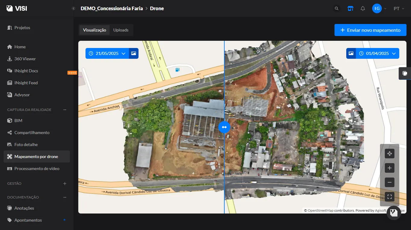
In recent years, drones have changed the way geospatial data is captured on a large scale. In construction and jobsite management, one of the most useful products generated from these images is orthomosaics.
In this post, we will talk about what this term means and why it becomes a reliable tool for measurements on your construction site.
What is an orthomosaic (and why is it more than just a photo)?
Think of an orthomosaic as a continuous aerial map of your jobsite.
In practice, the drone flies over the area and captures hundreds of high-resolution photos. Then, software, such as Visi by Construct IN, processes these images, corrects deformations, and "stitches" everything together into a single visual base, forming a large, continuous image with a consistent scale, ready for reading and measurements.
This correction step is what separates an orthomosaic from an ordinary aerial photo. In a normal photo, the camera tilt and terrain relief create perspective distortions: objects can appear shifted or different in size depending on the angle.
In the orthomosaic, these distortions are adjusted so that each point appears in its correct position, just like on a map.
And here comes an important concept: the orthophoto (or orthoimage). It is an individual photo that has already undergone this geometric correction "treatment", as if it had been digitally aligned and adjusted to represent the terrain with precision. In other words, the orthophoto is the corrected unit.
The orthomosaic, in turn, is the final result: the union of several corrected orthophotos into a single complete image of the construction site, with enough continuity and accuracy to support decisions and measurements on site.
The secret to accuracy: Ground Control Points (GCPs)
The big question when it comes to drone measurement is simple: how to ensure that the image matches the reality of the ground?
Accuracy depends on flight factors (altitude, overlap, image quality), but the most decisive element is the correct use and distribution of GCPs.
What are GCPs?
GCPs (Ground Control Points) are the safest way to "lock" the accuracy of an orthomosaic.
You can think of them as physical points on the ground that ensure the map generated by the drone aligns with reality, rather than just being "approximate."
In practice, it works like this: before the flight, the team marks a few points on the jobsite with already known coordinates. These points become references for the software during processing, increasing the accuracy and precision of the orthomosaic's georeferencing.
How are these points defined?
They need to appear clearly in the drone images. Therefore, they are usually marked on the ground with a highly visible "X" or cross, using a color that contrasts with the ground.
Then, the exact coordinates of each point are measured in the field with high-precision GNSS equipment, such as RTK, which delivers millimeter-level accuracy.
Where should GCPs be placed to ensure a good result?
The distribution of GCPs is just as important as the measurement. To improve the accuracy of the orthomosaic, the ideal approach is to spread these points across the entire area, with special attention to borders/vertices and also the central region.
When GCPs are concentrated in just one area, the map might look good at that specific spot, but it tends to lose accuracy in more distant areas, creating "weak zones" in the rest of the jobsite.
Practical applications in jobsite management
When the orthomosaic is generated with quality, it stops being just an aerial image and becomes a reliable base to measure, record, and monitor the construction site with much greater clarity.
1) Safer measurements and surveys
With the orthomosaic, you can make measurements directly on the jobsite map, with a consistent scale:
Measurement of distances and areas to check layout, access, work fronts, and execution boundaries.
Volume calculation based on delimitations on the mapping itself, helping to estimate and validate earthmoving and material piles.
Extraction of coordinates and details of the terrain and the construction site, supporting surveys and validations with positional precision when the product has been well georeferenced.
2) Full reading of the jobsite in a single map
Instead of relying on isolated photos and fragmented records, the orthomosaic delivers a continuous and navigable view of the entire area, making it easier to:
Identify interferences and terrain changes;
Quickly locate critical points;
Understand the overall context without losing details.
3) Monitoring and documenting construction progress
The orthomosaic also works as a technical record of the construction site:
Documents the construction site in just a few minutes, with a complete overview of what has been executed;
Creates a consistent visual history for alignment among teams, managers, and stakeholders;
Supports faster decisions, including in remote management.
Create construction orthomosaics with Visi
Visi is a practical management tool based on reality capture to ensure greater transparency of the construction site.
In the Drone mapping feature, using the drone's high-resolution photos, the platform automatically combines the images to generate a navigable and precise orthomosaic, allowing you to view the entire jobsite on an interactive map.
Additionally, Visi:
Defines the route and lets the drone make the automatic flight to capture several high-resolution photos. Then, just upload the images to VISI, which automatically combines everything and generates an interactive map. Documents in minutes and visualizes the entire terrain — with every detail recorded;
Enables comparing maps by date, analyzing progress side-by-side:
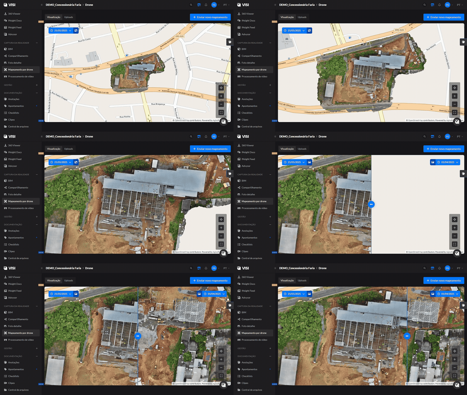
Helps identify changes in terrain, work fronts, and attention points more quickly, including in remote management;
In addition to mapping, Visi integrates other reality capture technologies such as 360° ground images, captured with 360° cameras, and aerial images with drones.
In recent years, drones have changed the way geospatial data is captured on a large scale. In construction and jobsite management, one of the most useful products generated from these images is orthomosaics.
In this post, we will talk about what this term means and why it becomes a reliable tool for measurements on your construction site.
What is an orthomosaic (and why is it more than just a photo)?
Think of an orthomosaic as a continuous aerial map of your jobsite.
In practice, the drone flies over the area and captures hundreds of high-resolution photos. Then, software, such as Visi by Construct IN, processes these images, corrects deformations, and "stitches" everything together into a single visual base, forming a large, continuous image with a consistent scale, ready for reading and measurements.
This correction step is what separates an orthomosaic from an ordinary aerial photo. In a normal photo, the camera tilt and terrain relief create perspective distortions: objects can appear shifted or different in size depending on the angle.
In the orthomosaic, these distortions are adjusted so that each point appears in its correct position, just like on a map.
And here comes an important concept: the orthophoto (or orthoimage). It is an individual photo that has already undergone this geometric correction "treatment", as if it had been digitally aligned and adjusted to represent the terrain with precision. In other words, the orthophoto is the corrected unit.
The orthomosaic, in turn, is the final result: the union of several corrected orthophotos into a single complete image of the construction site, with enough continuity and accuracy to support decisions and measurements on site.
The secret to accuracy: Ground Control Points (GCPs)
The big question when it comes to drone measurement is simple: how to ensure that the image matches the reality of the ground?
Accuracy depends on flight factors (altitude, overlap, image quality), but the most decisive element is the correct use and distribution of GCPs.
What are GCPs?
GCPs (Ground Control Points) are the safest way to "lock" the accuracy of an orthomosaic.
You can think of them as physical points on the ground that ensure the map generated by the drone aligns with reality, rather than just being "approximate."
In practice, it works like this: before the flight, the team marks a few points on the jobsite with already known coordinates. These points become references for the software during processing, increasing the accuracy and precision of the orthomosaic's georeferencing.
How are these points defined?
They need to appear clearly in the drone images. Therefore, they are usually marked on the ground with a highly visible "X" or cross, using a color that contrasts with the ground.
Then, the exact coordinates of each point are measured in the field with high-precision GNSS equipment, such as RTK, which delivers millimeter-level accuracy.
Where should GCPs be placed to ensure a good result?
The distribution of GCPs is just as important as the measurement. To improve the accuracy of the orthomosaic, the ideal approach is to spread these points across the entire area, with special attention to borders/vertices and also the central region.
When GCPs are concentrated in just one area, the map might look good at that specific spot, but it tends to lose accuracy in more distant areas, creating "weak zones" in the rest of the jobsite.
Practical applications in jobsite management
When the orthomosaic is generated with quality, it stops being just an aerial image and becomes a reliable base to measure, record, and monitor the construction site with much greater clarity.
1) Safer measurements and surveys
With the orthomosaic, you can make measurements directly on the jobsite map, with a consistent scale:
Measurement of distances and areas to check layout, access, work fronts, and execution boundaries.
Volume calculation based on delimitations on the mapping itself, helping to estimate and validate earthmoving and material piles.
Extraction of coordinates and details of the terrain and the construction site, supporting surveys and validations with positional precision when the product has been well georeferenced.
2) Full reading of the jobsite in a single map
Instead of relying on isolated photos and fragmented records, the orthomosaic delivers a continuous and navigable view of the entire area, making it easier to:
Identify interferences and terrain changes;
Quickly locate critical points;
Understand the overall context without losing details.
3) Monitoring and documenting construction progress
The orthomosaic also works as a technical record of the construction site:
Documents the construction site in just a few minutes, with a complete overview of what has been executed;
Creates a consistent visual history for alignment among teams, managers, and stakeholders;
Supports faster decisions, including in remote management.
Create construction orthomosaics with Visi
Visi is a practical management tool based on reality capture to ensure greater transparency of the construction site.
In the Drone mapping feature, using the drone's high-resolution photos, the platform automatically combines the images to generate a navigable and precise orthomosaic, allowing you to view the entire jobsite on an interactive map.
Additionally, Visi:
Defines the route and lets the drone make the automatic flight to capture several high-resolution photos. Then, just upload the images to VISI, which automatically combines everything and generates an interactive map. Documents in minutes and visualizes the entire terrain — with every detail recorded;
Enables comparing maps by date, analyzing progress side-by-side:
Helps identify changes in terrain, work fronts, and attention points more quickly, including in remote management;
In addition to mapping, Visi integrates other reality capture technologies such as 360° ground images, captured with 360° cameras, and aerial images with drones.
Sobre o autor
Tales Silva
CEO & founder, Construct IN
Tales Silva é Engenheiro Civil formado pela PUCRS (2016) e possui MBA Executivo com foco em marketing pela ESPM-Sul (2019). Tem experiência em projetos estruturais e em construções industrializadas. É fundador e CEO da Construct IN, construtech que oferece uma plataforma de gestão e documentação de obras por meio de imagens 360º.
cOMPARTILHE NAS REDES
Recomendado para você
carregar mais ↓


Subscribe to our newsletter
Explore nossas soluções
Entre em contato e descubra como a captura da realidade e dados centralizados podem ser a solução para a gestão de suas obras.
