Home > From Construction to Retail
From Construction to Retail: The Sectors Leading the Reality Capture Revolution
The Reality Capture revolution replaces the uncertainty of analog tools with the certainty of a Digital Twin. This transition from management by estimation to management by evidence is about a new way of deciding that unites leaders from different sectors, guided by efficiency.
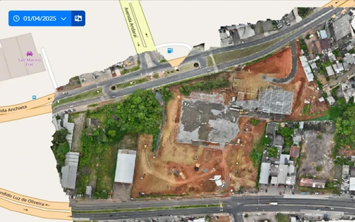
Reality capture has transcended the boundaries of civil construction, proving to be a horizontal technology with the power to redefine efficiency, safety, and asset management in any sector that relies on physical infrastructure.
The ability to create an accurate digital replica of the real world is not a luxury, but a strategic necessity for leaders seeking to optimize operations, mitigate risks, and make decisions based on concrete data.
Different sectors are discovering how to transform their physical assets into sources of business intelligence. Analyzing how they apply reality capture offers valuable lessons and reveals the universal potential of this digital revolution.
Construction and Infrastructure: Optimizing the Project Life Cycle
Civil construction and large infrastructure projects represent the epicenter of reality capture applications. The inherent complexity, high investments, and elevated risks make these sectors a fertile ground for data-based optimization.
The disconnect between the project office and the construction site has historically been one of the greatest sources of inefficiency, rework, and budget overruns, and this is precisely the main issue solved by Reality Capture.
Construction Industry: A New Era of Efficiency and Governance
In civil construction, Reality Capture represents a fundamental paradigm shift: the transition from a reactive management model, based on ad-hoc and subjective inspections, to a predictive and data-driven governance. The technology not only optimizes existing tasks; it transforms the construction site—traditionally an analog and difficult-to-measure environment—into a dynamic and quantifiable digital asset.
This transformation materializes through short verification cycles. Continuous monitoring with 360° images and aerial mapping with drones allow for the creation of a visual and interactive timeline of the construction site.
By overlaying these faithful records of reality onto BIM models, management stops merely putting out fires and begins to anticipate problems. Deviation analysis, which was previously a complex task relying on information provided by the field team, becomes a systematic process that can be performed autonomously and remotely, allowing for tolerance management at scale, ensuring dimensional compliance and execution quality in a proactive manner.
The most disruptive impact, however, lies in the creation of a Traceable Reality™. Each capture — whether a highly accurate point cloud or a georeferenced 360° image — functions as a digital notary record of the construction site. This single source of truth serves as an indisputable technical foundation for all contractual events.
Payment measurements are accelerated, the need for contractual amendments is proven with visual evidence, and disputes (claims) are mitigated even before they arise, raising the level of legal certainty and transparency for the relationship between the construction company, clients, and suppliers.
Finally, the process culminates in the delivery of a value-added asset. The project is not only physically delivered but accompanied by its as-built digital twin, a legacy of accurate data. This comprehensive record not only simplifies the operation and maintenance phase but also redefines the long-term value of the development, establishing a solid and reliable foundation for its entire lifespan.
Infrastructure: Security and Large Scale Management
Infrastructure projects, such as highways, railways, and bridges, pose unique monitoring challenges due to their vast geographical extension. Reality capture with drones and mobile scanners replaces traditional methods — such as manual topography with total stations and structural inspections with lane closures and aerial baskets — with fast, complete, and safe digital mapping.
With this technology, it is possible to conduct surveys of linear corridors in a fraction of the time, monitor earthwork volumes with precision, and inspect critical structures without putting crews at risk or impacting traffic.
In addition to construction monitoring, periodic captures feed the asset's digital twin, allowing for the detection of wear and deformation for predictive maintenance. This not only prevents failures but also optimizes operations and extends the lifespan of the entire infrastructure, ensuring centralized, data-driven management.
Retail Expansion: Standardization and Agility in Store Roll-out
For retail chains, speed and consistency in expansion are crucial. The roll-out process — replicating a standard store design across multiple locations — is a logistical challenge involving tight deadlines and the need to ensure a uniform brand experience.
The lack of accurate documentation regarding the existing conditions of rented properties is a constant source of delays and unexpected costs. Reality capture solves this problem decisively, allowing architecture teams to obtain a complete as-is survey of a new commercial location in a matter of hours, not days.
This accurate data is imported into design software, allowing the adaptation of the standard layout to be done with the certainty that there will be no conflicts with existing beams, columns, or utilities.
Additionally, digital twins are revolutionizing how retailers plan and optimize their layouts. Companies can create virtual replicas of their stores and simulate customer flow, test different shelf arrangements, and analyze the impact of new merchandising strategies before investing in physical implementation.
Lowe's, for example, used this approach to reduce the distance traveled by customers by 22% and increase complementary purchases by 18%, demonstrating a clear and measurable ROI.
Industry: Precision in Maintenance Shutdowns and Adaptation Projects
In sectors such as oil and gas, petrochemicals, and manufacturing, where every minute of downtime represents an exorbitant cost, Reality Capture introduces a principle of digital certainty to critical operations. The technology acts both in creating baseline models and in their continuous validation, ensuring that decisions are always guided by the most current condition of the asset.
For scheduled maintenance shutdowns, creating an accurate Digital Twin of the plant shifts the challenge from the field to the virtual environment. There, equipment replacement logistics can be planned and validated to the millimeter.
However, the true efficiency gain lies in complementarity: a reality capture performed immediately before the shutdown serves as the final validation. It ensures that the physical environment — where equipment might have been moved or a temporary structure installed — matches the digital plan exactly, eliminating unforeseen issues and additional costs during execution.
Similarly, in modernization projects (retrofit), where the lack of reliable documentation is a chronic obstacle, the technology provides the foundation for success. Creating an intelligent BIM model from captured reality ensures the correct starting point. From there, recurring captures throughout the project ensure that the new design remains perfectly compatible with the existing structure at every stage, enabling safer, faster, and more cost-effective adaptation projects.
Asset and Territory Management: From Physical Inventory to Predictive Intelligence
Effective asset and territory management fundamentally depends on one piece of information: knowing exactly what you have and where it is. Since critical decisions are made based on outdated, incomplete, or non-existent information, the result is inefficiency, high costs, and missed opportunities.
In the different situations that involve this context, such as managing a portfolio of commercial buildings, a vast mining area, or a high-tech farm, Reality Capture adds a layer of digital intelligence to replace analog and unstable processes, such as a manual inventory, with the certainty of a precise, navigable, and dynamic digital record.
Facilities Management and Building Maintenance
In facilities management, the traditional starting point is fragmented information and often outdated 2D plans. Reality Capture transforms this scenario by enabling the creation of a Digital Twin of the asset: a navigable 3D model identical to reality.
With it, building managers can instantly locate any component — from an HVAC valve to a network point — and access all its technical documentation with a single click.
This virtual replica drastically optimizes intervention planning, reducing maintenance team response times and minimizing system downtime. The true leap in quality occurs when the Digital Twin is integrated with sensors (IoT), elevating management from a reactive level to a predictive model.
Instead of fixing failures, the system begins to anticipate problems based on real-time performance data, proactively scheduling maintenance and avoiding shutdowns that impact business operations.
This same digital foundation is an invaluable resource for asset safety and risk management. With a 3D model true to reality, it is possible to plan optimized evacuation routes, simulate emergency scenarios, determine the ideal positioning of security cameras to eliminate blind spots, and train crisis response teams in a virtual environment identical to the real one — a level of proactive planning indispensable for managing large-crowd events and critical infrastructure.
Territory Management: Precision in Mining and Agriculture
In sectors that manage vast territories, such as mining and agriculture, precision on a large scale redefines profitability.
In mining, capturing with drones equipped with LiDAR or photogrammetric sensors has revolutionized topography and production control. The technology allows the creation of highly accurate digital terrain models, even under dense vegetation, optimizing mine planning and slope monitoring to ensure safety. One of its most impactful applications is the precise and frequent calculation of the volume of ore stockpiles, which eliminates the uncertainties of manual inventory and improves production reconciliation.
In precision agriculture, the logic is similar, but focused on crop health. Drones capture multispectral imagery that reveals crop vigor at a level of detail impossible for the human eye. This data allows for the localized application of fertilizers and pesticides exactly where they are needed, which optimizes input use, reduces costs, and minimizes environmental impact. Terrain analysis also informs irrigation management and harvest planning, maximizing crop yield.
High Precision Applications: From Public Safety to Media and Entertainment
There are Reality Capture applications where the goal is not to transform the future of a project, but rather to preserve, analyze, or replicate the present in a perfect and immutable way. In these fields, ranging from forensics and archaeology to visual effects, the captured reality is not a starting point for construction, but rather the final artifact: a backup of the truth, a record that freezes time.
Here, millimeter precision is not just a matter of efficiency, but of integrity. The technology serves as a bridge to ensure that a fact, a work of art, or a scene is not lost to the passage of time, the contamination of evidence, or the limits of manual digital creation.
Inheritance at Risk: The Digital Rescue Against Impermanence
Most of human history is told in stone, wood, and clay, but these materials are fragile witnesses, constantly threatened not only by the slow action of time, but by sudden catastrophes and conflicts.
The fire that devastated the Notre-Dame Cathedral in 2019 was a brutal reminder of this vulnerability. Reality Capture emerges, then, as a preservation and rescue tool: a way to create the digital backup of our collective heritage.
Before a disaster occurs, or degradation erases details forever, technology creates a high-fidelity Digital Twin. This file is not just a record; it is the source code for a faithful reconstruction, as seen in Paris, where previous scans became the foundation for the restoration.
In archaeology, the challenge is similar. Technology allows performing "digital excavations" on threatened sites, documenting each layer and artifact in 3D before the opportunity is lost, ensuring that knowledge is not buried twice.
This digitized heritage thus fulfills a dual mission: it serves as a precise manual for restoration specialists and, at the same time, transforms into portals of universal access, such as virtual museums, ensuring that humanity's legacy becomes, in fact, immortal and accessible to all.
Integrity in evidence: the testimony of the captured truth
The integrity of the crime scene is decisive for the integrity of justice. Every object, every mark, every distance is a piece of a complex puzzle. Reality Capture acts as the guardian of this integrity, creating a digital sanctuary of the scene: a perfect and immutable replica, frozen in time, immune to the contamination or degradation of evidence.
But its true power goes beyond preservation. Technology becomes a partner to the investigative mind. The "digital crime scene" is the stage where the detective's intuition is amplified. Free from physical limitations and the risk of altering evidence, the investigator can revisit the site as many times as necessary, test hypotheses, analyze trajectories, and visualize patterns that would be invisible in the chaos of the real environment. Technology does not provide the answers, but it creates the perfect environment for human deduction and genius to find them.
The same investigative logic extends to the reconstruction of complex accidents. Whether analyzing the debris trajectory of an aircraft or determining the causes of a structural collapse, technology offers experts a precise model for tests and simulations, fundamental for drafting conclusive reports.
The final destination of this "anatomy of truth" is often the courtroom. There, the 3D model is presented in a clear and interactive way, allowing the jury to "walk" through the scene and understand the facts with unprecedented clarity, ensuring that the verdict is built on the most solid foundation possible: reality itself.
Media and Entertainment (VFX): The Real as Raw Material for Fantasy
In the fantasy industry, the most valuable raw material is reality itself. For the impossible to feel real on a movie screen or in a video game, it must be built upon a foundation of visual truth. Reality Capture is the technology that extracts this essence from the physical world, allowing the DNA of the real to be injected directly into digital creation.
Locations, objects, and even actors are scanned with absolute fidelity, transforming into digital assets that serve as the foundation for composing new worlds. Instead of an artist modeling a historic building from scratch, for example, the team starts with its perfect digital replica.
This approach not only accelerates production; it triggers a fundamental shift in the creative process. By automating the fidelity of the real, the technology frees up the industry's most valuable resource: human imagination. Artists no longer need to spend their time recreating what already exists; they use that time to build what has never existed, starting from a base of perfect realism.
How to Choose the Ideal Reality Capture Solution for Your Goals
The decision to adopt Reality Capture is not a question of "if", but of "how". The market offers a spectrum of technologies, and for a strategic leader, the wrong choice can mean an oversized investment for a simple problem or, conversely, an imprecise tool for a task of millimetric rigor.
The key is to align technology with the objective. It's not about finding the best solution, but the right solution for the pain point that needs to be resolved. To this end, let's analyze the three main strategic approaches: Agile Management, Broad Vision, and Maximum Precision.
The Approach of Agile Management: 360° Cameras and SaaS Platforms
The Profile: Ideal for continuous monitoring of construction sites, progress documentation, and remote collaboration, where the goal is agility, low cost, and ease of use.
How It Works: 360° cameras capture spherical images of an environment in seconds. These images are organized in a software platform (SaaS), which links them to floor plans and creates a visual, interactive timeline of the project.
Strengths: Very low entry cost, minimal learning curve, and extremely fast capture speed. Allows anyone on the team to create immersive and detailed records.
Points of Attention: The images are spherical 2D visual records and do not generate a 3D point cloud, making them unsuitable for high-precision technical measurements. The 360° capture in itself is a visual record. Its management power is limited by the intelligence of the platform in which it is inserted.
The Visi Solution: Transforming the 360° Image into a Management Environment
The Visi by Construct IN platform starts with 360° capture, but elevates it to a new level, transforming the image into an active and intelligent workspace. The solution stands out by integrating Artificial Intelligence tools, such as the INsight Explorer, which automatically analyzes and highlights the points of the construction site where progress has occurred, optimizing inspections.
In addition, the platform centralizes all communication and control with Notes, Daily Work Reports (RDOs), Verification Sheets (FVS) and native integration with BIM and Schedule, ensuring that each image serves not only for viewing, but for managing, deciding, and acting.
The Broad Vision Approach: Photogrammetry with Drones
The Profile: Perfect for mapping large areas, such as in topographic surveys, earthworks monitoring, and facade or roof inspections, where a macro view with centimeter-level precision is sufficient.
How It Works: Drones capture a series of overlapping aerial photographs that, processed by specialized software, reconstruct a 3D model and an orthomosaic map of the terrain.
Strengths: Excellent balance between area coverage, precision, and cost. It is capable of mapping hundreds of hectares in a single day.
Points of Attention: Precision can be affected by lighting conditions (shadows, direct sunlight) and the technology cannot map the ground under dense vegetation. It requires knowledge in flight planning and data processing.
The Visi Solution: The Unified Vision from Macro to Micro
The Drone Mapping solution from Construct IN simplifies one of the most complex steps of the process: data processing is automated by the Visi platform. But its main differentiator is integration.
The drone map is not an isolated tool. Within Visi, it connects to 360° ground images, offering the manager a complete and unified perspective of the project. It is possible to navigate from the macro view of earthmoving progress on the map to checking an installation detail inside the building in a single environment, ensuring much more contextualized and strategic decision-making.
The Maximum Precision Approach: Laser Scanning (LiDAR)
The Profile: Indispensable for applications where millimeter-level precision is non-negotiable. Use cases include the creation of as-builts for industrial retrofits, dimensional quality control, and historical heritage documentation.
How It Works: The equipment emits laser pulses to measure millions of points on a surface, creating a dense and extremely accurate point cloud.
Strengths: Extremely high reliability and precision. Because it emits its own light, it operates in any lighting condition, including total darkness. It can penetrate small openings in vegetation to map the actual terrain.
Points of Attention: Considerably higher equipment and professional costs. Field capture can be more time-consuming, as it requires positioning the scanner across multiple stations. It generates massive data files that require robust hardware and software for processing.
The choice between these alternatives is not mutually exclusive. The smartest approach often involves combining technologies. A project can use drones for the initial topographic survey, 360° cameras for daily progress tracking, and hire a laser scanning service for the final as-built verification of critical areas. The unifying, and most important, factor is the platform where all this data converges.